
Wissahickon Advocacy Groups Fight Stormwater One Project at a Time
by
Ruffian Tittmann, Executive Director, Friends of the Wissahickon, and Gail Farmer, Executive Director, Wissahickon Trails
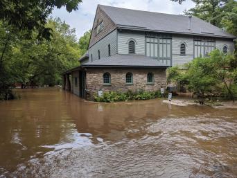
Photo by Jamie Stewart
Tropical Storm Isaias flooded the Four Mills Barn office of Wissahickon Trails in Ambler in early August.
When it rains, it pours — and then it floods. It’s an all-too familiar pattern of more frequent, significant rain events, like this summer’s Tropical Storm Isaias, brought on by climate change.
A well-functioning watershed captures, stores, and slowly releases rainfall (and snowmelt) into a body of water such as a creek, stream, or river. Continuous development within the 64-square-mile area of the Wissahickon Watershed in Montgomery and Philadelphia counties exponentially increases surface runoff and overland flow. The increased flow we see during and after storm events erodes the streambanks throughout the watershed, adding sediment and pollution and ultimately degrading the habitat and water quality of the Wissahickon Creek and its tributaries.
To address the impact of this growing challenge, Friends of the Wissahickon and Wissahickon Trails (formerly the Wissahickon Valley Watershed Association) continue to work with our regional partners and invest millions of dollars in capital improvements throughout the Wissahickon. Here are a few:
- FOW’s much-awaited Forbidden Drive Streambank Stabilization Project, completed last fall, secured the major streambank collapse sites along the Philadelphia section of the Wissahickon Creek near Valley Green Inn, the Mt. Airy Avenue pedestrian bridge, and the Kitchens Lane Bridge. Conservation-driven construction practices used soil lifts (similar to terraced “steps”) that crews populated with native seeds and plants.
- Over time, the mature plantings will naturalize and become established growth that will support the multifaceted engineering work, while becoming part of the landscape and reducing the force of water coming off the stream and hillside.
- The future Lavender Trail (Gully North) Project is another large-scale example of FOW’s commitment to protect the creek’s quality. It will target one of two major erosion sites on this trail — around the Chestnut Hill Avenue/Crefeld Street interchange, which is one of the largest sources of sediment discharge into the creek. We hope that the design and permits for this stabilization and planting project will be completed later this year.
- After more than five years of planning, Wissahickon Trails is spearheading the Wissahickon Headwaters Stream and Riparian Restoration Project. This will restore and stabilize the Wissahickon Creek in the PECO right-of-way power line corridor.
We will partner with PECO on the project, along with Upper Gwynedd Township and Merck.
Once the work is completed, we will be able to turn this property along a highly eroded stretch of the creek into an actual floodplain. This will slow down the force of the water and allow it to percolate into the ground, catching it where it hits, instead of flowing downstream. Construction was supposed to have begun in March, but has been delayed by the coronavirus pandemic. Crews are currently working to stabilize the area and avoid further damage from flood waters; they hope to complete the work in the fall. Flood tolerant plantings will be installed, which, over time, will look and work as a functioning ecosystem.
Conserving land protects the Wissahickon, a source of drinking water for a third of Philadelphians. Through this work, we also maintain the area’s infrastructure, along with habitats for local wildlife surrounding and within the creek.
As flood watches continue to make headlines in our region, FOW and Wissahickon Trails will continue to work with watershed groups and municipalities, such as the 12-member Wissahickon Clean Water Partnership. Their planning, research, and advocacy efforts will advance the future resiliency of this vital watershed.